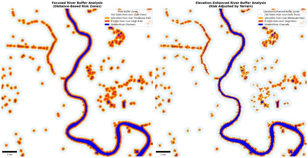
 This script prepares core geospatial layers for analyzing flood-prone areas in Bangkok. It exports elevation, land cover (water and built-up areas), and October 2023 rainfall data to local GeoTIFF files using Google Earth Engine and geemap. The outputs are used for flood vulnerability analysis, especially in low-lying, urbanized zones.
## Output File
`/data/bangkok_flood_native`
## Requirements
| Requirement | Details |
| ------------------- | -------------------------------------------------------------------------------------------------------------------- |
| **Software** | Python 3.x, Earth Engine Python API, geemap |
| **Earth Engine** | Enabled Google Earth Engine account ([https://signup.earthengine.google.com](https://signup.earthengine.google.com)) |
| **Python Packages** | geemap, earthengine-api, os, ee |
| **Internet** | Required for Earth Engine data download |
## Files Created
| Filename | Description | Resolution |
| --------------------------------- | --------------------------------------------- | ---------- |
| **dem\_srtm.tif** | Elevation data from SRTM (clipped to AOI) | 30 m |
| **dw\_water\_built\_mask.tif** | Masked Dynamic World image (1=Water, 2=Built) | 10 m |
| **rainfall\_oct2023\_chirps.tif** | CHIRPS total rainfall for Oct 2023 | \~5.5 km |
## High-Level Workflow Steps
### 1. Setup and Define AOI
Define Bangkok's location and buffer by 10 km to create an Area of Interest (AOI).
### 2. Export SRTM Elevation
* Use the **USGS/SRTMGL1\_003** dataset
* Export as `dem_srtm.tif` at 30 m resolution
### 3. Export Landcover (Water & Built)
* Use the **Google Dynamic World** dataset for 2023
* Use `.mode()` to get the most frequent class
* Remap values: 0 → Water (1), 6 → Built (2), others → 0
* Export as `dw_water_built_mask.tif` at 10 m resolution
### 4. Export Rainfall
* Use **CHIRPS Daily** rainfall dataset
* Sum rainfall for October 2023
* Export as `rainfall_oct2023_chirps.tif` at \~5.5 km resolution
## Flood Risk Classification
This script generates a flood risk classification map of Bangkok using:
* **SRTM DEM (Elevation at 30m)** to identify low-lying areas (\< 5 meters elevation)
* **Dynamic World Landcover (10m)** to locate built-up and water regions
### Output: Flood-Prone Map
You get a matplotlib map showing flood-prone areas based on both elevation and landcover:
#### Legend Explained
| Color | Label | Meaning |
| ----------- | ------------------ | ------------------------------------------------------------ |
| 🔵 **Blue** | Low-lying Water | Areas classified as water in DW and below 5 meters elevation |
| 🔴 **Red** | Low-lying Built-up | Areas classified as built-up and below 5 meters elevation |
***
This script prepares core geospatial layers for analyzing flood-prone areas in Bangkok. It exports elevation, land cover (water and built-up areas), and October 2023 rainfall data to local GeoTIFF files using Google Earth Engine and geemap. The outputs are used for flood vulnerability analysis, especially in low-lying, urbanized zones.
## Output File
`/data/bangkok_flood_native`
## Requirements
| Requirement | Details |
| ------------------- | -------------------------------------------------------------------------------------------------------------------- |
| **Software** | Python 3.x, Earth Engine Python API, geemap |
| **Earth Engine** | Enabled Google Earth Engine account ([https://signup.earthengine.google.com](https://signup.earthengine.google.com)) |
| **Python Packages** | geemap, earthengine-api, os, ee |
| **Internet** | Required for Earth Engine data download |
## Files Created
| Filename | Description | Resolution |
| --------------------------------- | --------------------------------------------- | ---------- |
| **dem\_srtm.tif** | Elevation data from SRTM (clipped to AOI) | 30 m |
| **dw\_water\_built\_mask.tif** | Masked Dynamic World image (1=Water, 2=Built) | 10 m |
| **rainfall\_oct2023\_chirps.tif** | CHIRPS total rainfall for Oct 2023 | \~5.5 km |
## High-Level Workflow Steps
### 1. Setup and Define AOI
Define Bangkok's location and buffer by 10 km to create an Area of Interest (AOI).
### 2. Export SRTM Elevation
* Use the **USGS/SRTMGL1\_003** dataset
* Export as `dem_srtm.tif` at 30 m resolution
### 3. Export Landcover (Water & Built)
* Use the **Google Dynamic World** dataset for 2023
* Use `.mode()` to get the most frequent class
* Remap values: 0 → Water (1), 6 → Built (2), others → 0
* Export as `dw_water_built_mask.tif` at 10 m resolution
### 4. Export Rainfall
* Use **CHIRPS Daily** rainfall dataset
* Sum rainfall for October 2023
* Export as `rainfall_oct2023_chirps.tif` at \~5.5 km resolution
## Flood Risk Classification
This script generates a flood risk classification map of Bangkok using:
* **SRTM DEM (Elevation at 30m)** to identify low-lying areas (\< 5 meters elevation)
* **Dynamic World Landcover (10m)** to locate built-up and water regions
### Output: Flood-Prone Map
You get a matplotlib map showing flood-prone areas based on both elevation and landcover:
#### Legend Explained
| Color | Label | Meaning |
| ----------- | ------------------ | ------------------------------------------------------------ |
| 🔵 **Blue** | Low-lying Water | Areas classified as water in DW and below 5 meters elevation |
| 🔴 **Red** | Low-lying Built-up | Areas classified as built-up and below 5 meters elevation |
***
Access the complete code, step-by-step instructions, and interactive notebook in Nika Hub.
View Full Solution →