> ## Documentation Index
> Fetch the complete documentation index at: https://docs.nikaplanet.com/llms.txt
> Use this file to discover all available pages before exploring further.

# Overview

> Learn about how NikaPlanet works and how to get started

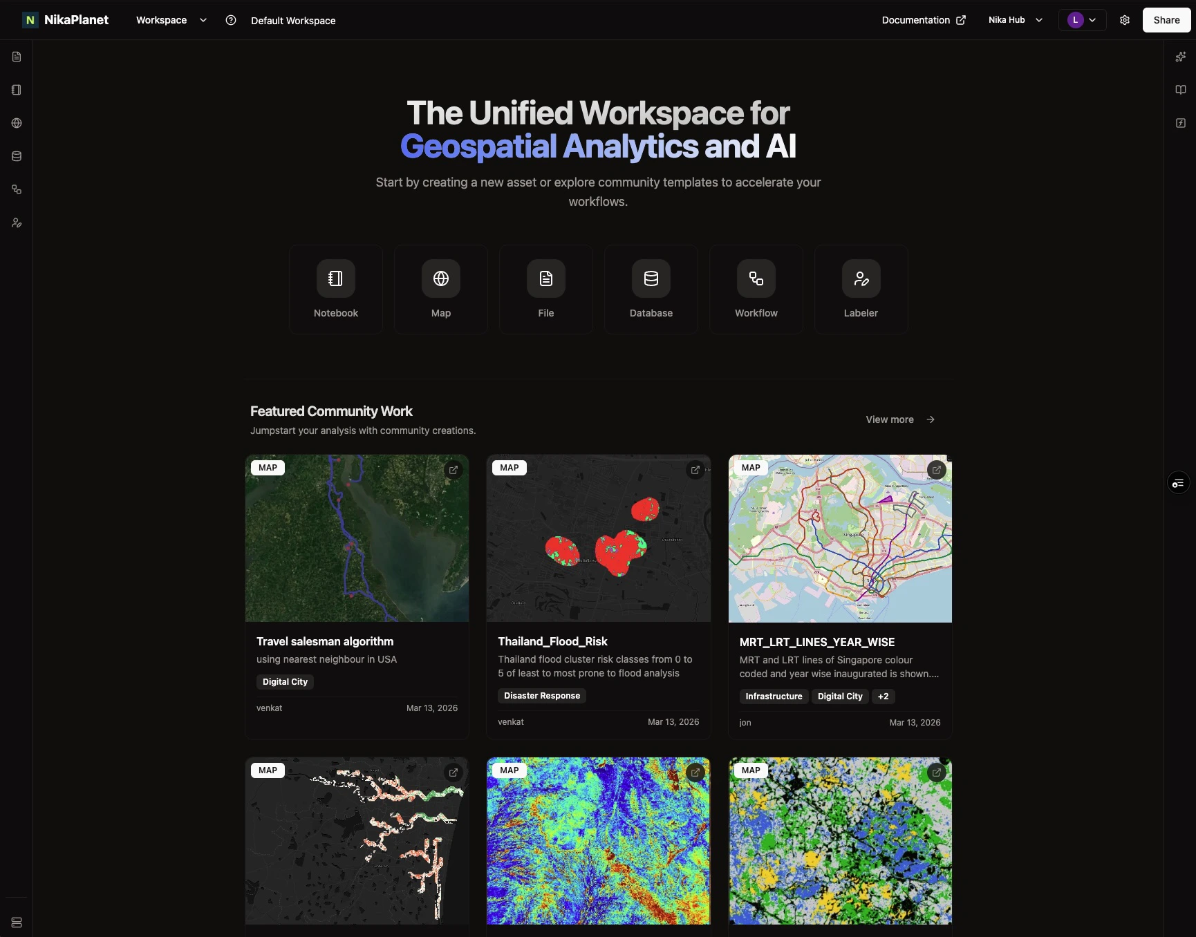
<img src="https://mintcdn.com/nika/ylSFZ5WH2TFtSw7p/nika-planet/nika-planet.jpg?fit=max&auto=format&n=ylSFZ5WH2TFtSw7p&q=85&s=c8c2b0dd3363e91beb99a30f3b812c3b" alt="NikaPlanet Interface" width="1730" height="1356" data-path="nika-planet/nika-planet.jpg" />

NikaPlanet is a cloud GIS platform for geospatial data analysis, visualization, and application development. Build powerful maps, dashboards, and data-driven applications with intelligent AI agent.

<div style={{ textAlign: 'center', margin: '2rem 0' }}>
  <div
    style={{ 
position: 'relative', 
width: '100%', 
maxWidth: '800px', 
margin: '0 auto',
borderRadius: '12px',
overflow: 'hidden',
boxShadow: '0 10px 30px rgba(0, 0, 0, 0.1)'
}}
  >
    <iframe width="100%" height="450" src="https://www.youtube.com/embed/5uhF863lWxM?si=ZM_I35-4jfNbL85s" title="Nika Geospatial Highlights" frameBorder="0" allow="accelerometer; autoplay; clipboard-write; encrypted-media; gyroscope; picture-in-picture; web-share" allowFullScreen style={{ display: 'block' }} />
  </div>

  <p
    style={{ 
marginTop: '1rem', 
fontSize: '0.9rem', 
color: 'var(--color-text-secondary)',
fontStyle: 'italic'
}}
  >
    Watch this video to learn more about Nika's powerful geospatial capabilities
  </p>
</div>

## Get Started

<Steps>
  <Step title="Sign Up">
    Create your account at [planet.nika.eco](https://planet.nika.eco) with your email.
  </Step>

  <Step title="Create Your First Workspace">
    Set up a workspace to organize your geospatial projects and collaborate with your team.
  </Step>

  <Step title="Explore the Guides">
    Follow the [step-by-step guides](/guides/tutorials/getting-started-with-nikaworkspace) to learn how to use each feature.
  </Step>
</Steps>

## Product Offerings

Nika provides 10 powerful tools to transform your geospatial and data analysis workflows.

<Columns cols={2}>
  <Card title="NikaWorkspace" icon="book-open" href="/nika-planet/nika-workspace">
    Advanced geospatial data analysis platform for with PBs of dataset, directly integrated with AI agent.
  </Card>

  <Card title="NikaNotebook" icon="book" href="/nika-planet/nika-notebook">
    Scalable Jupyter notebook alternative for teams to work together to build and test forefront geospatial workloads with pre-installed GDAL and CUDA.
  </Card>

  <Card title="NikaHub" icon="images" href="/nika-planet/nika-hub">
    Showcase and discover published apps, solutions, maps, and notebooks from our community.
  </Card>

  <Card title="NikaMap" icon="globe" href="/nika-planet/nika-map">
    World's first multi-user editable map that can visualize millions of vector polygons, GBs of raster images, even drone images out of box.
  </Card>

  <Card title="NikaDBMS" icon="database" href="/nika-planet/nika-dbms">
    Advanced geospatial database management system with AI-powered SQL generation and seamless workspace integration.
  </Card>

  <Card title="NikaFlow" icon="water" href="/nika-planet/nika-flow">
    One click deploy python script as serverless function, and use AI agent to create a flow diagram using these functions for data processing engineering.
  </Card>

  <Card title="NikaLabeler" icon="pencil" href="/nika-planet/nika-labeler">
    Annotate, preprocess imaged based datasets team labelling capability. with direct support of GEOTIFF format on top of traditional images.
  </Card>

  <Card title="NikaStudio" icon="computer" href="/nika-planet/nika-studio">
    Build map and dashboard applications with Nika's AI agent with brilliant UI and automated serverless backend.
  </Card>

  <Card title="NikaGeoEngine" icon="code" href="/nika-geoengine/overview">
    One-click deploy Python scripts as geoprocessing functions to multiple platform at once.
  </Card>

  <Card title="NikaDashboard" icon="chart-line" href="/nika-planet/nika-dashboard">
    Drag widget and file to create an operational dashboard that bridges both reliability and performace upon large amount of data to showcase.
  </Card>
</Columns>

## Key Features

Everything you need to create world-class geospatial applications.

<Columns cols={2}>
  <Card title="AI Agent" icon="brain">
    Nika's intelligent AI assistant that understands your data and helps you build faster.
  </Card>

  <Card title="Maps & Visualization" icon="map">
    Create interactive maps and powerful data visualizations with ease.
  </Card>

  <Card title="Analytical Databases" icon="database">
    Build comprehensive dashboards to monitor and analyze your data.
  </Card>

  <Card title="Geospatial Analysis" icon="location-dot">
    Advanced spatial analysis tools for location-based insights.
  </Card>
</Columns>

## Enterprise Features

Built for organizations that need enterprise-grade geospatial solutions.

<Columns cols={2}>
  <Card title="Advanced Geoprocessing" icon="tree">
    Built-in functions that match ArcGIS tools, including pansharpening, superresolution, SAM2, acolite, buffer, centroid, and 200+ more geoprocessing operations for professional GIS workflows.
  </Card>

  <Card title="Single Sign-On (SSO)" icon="shield-check">
    Seamless integration with your organization's Active Directory, LDAP, or other identity providers. Enable secure team collaboration with centralized authentication and role-based access control.
  </Card>

  <Card title="Data Migration Support" icon="cloud-arrow-up">
    Dedicated support engineers to help migrate terabytes of data from any cloud service provider (AWS, Azure, GCP) or desktop systems. Get expert assistance for complex data transfers and format conversions.
  </Card>

  <Card title="On-Premise Deployment" icon="server">
    Deploy Nika on your own infrastructure for maximum data sovereignty and compliance. Full control over your geospatial data with enterprise-grade security, backup, and disaster recovery capabilities.
  </Card>
</Columns>
