
Overview
NikaLabeler is the world’s first and only geospatial-friendly image annotation platform designed specifically for top-down satellite and drone imagery. Built for efficiency and collaboration, it enables teams to annotate geospatial datasets with real-time synchronization, AI-powered assistance, and seamless integration with NikaWorkspace’s data lake.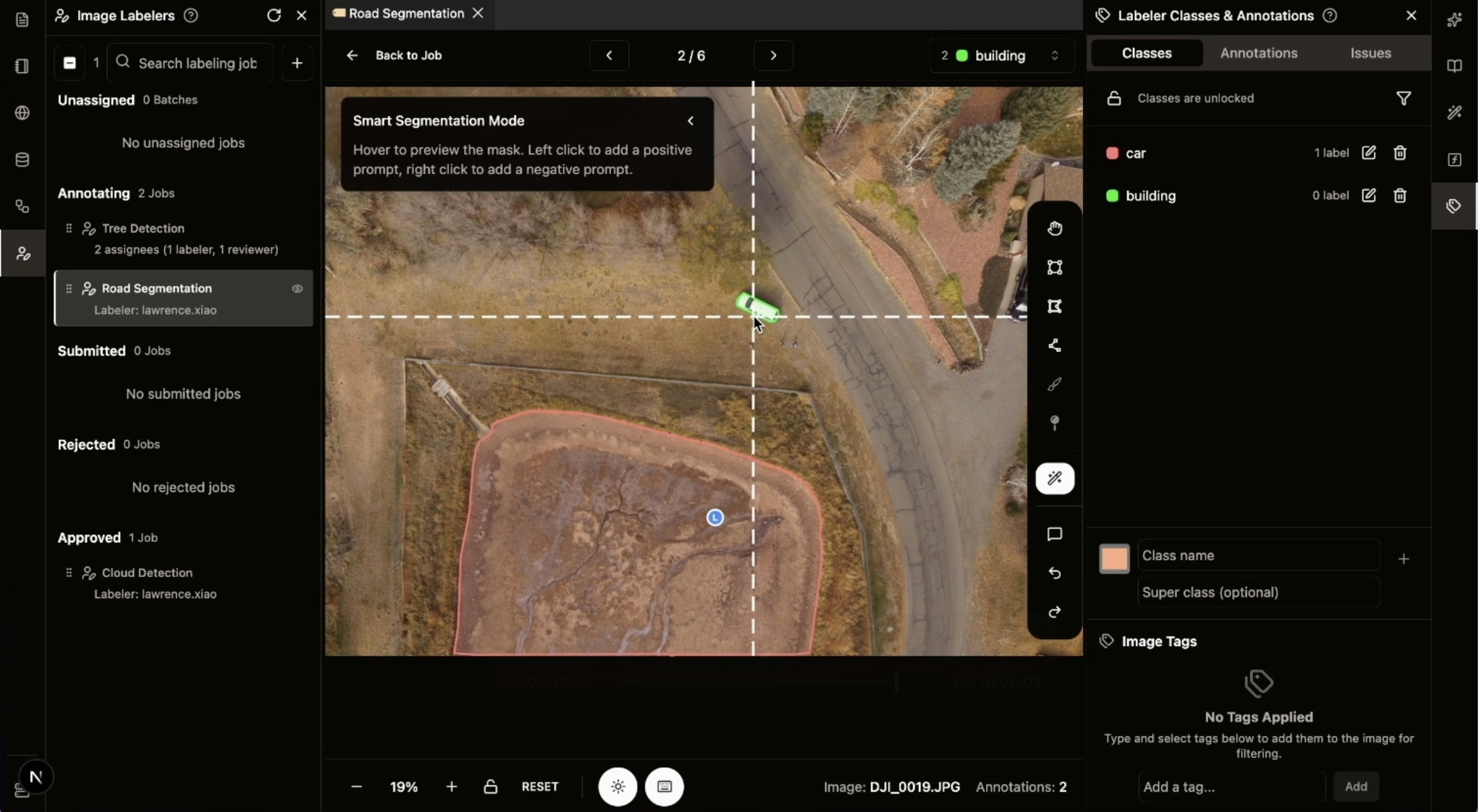
Key Features
Real-time Co-annotation
- Live Collaboration: Multiple users can annotate simultaneously with real-time sync
- Cursor Synchronization: See team members’ cursor positions in real-time
- Live State Updates: Approve/reject states and comments sync instantly across all users
- Progress Tracking: Real-time progress bar at the top showing annotation completion
Annotation Format Import/Export
- Import/Export: Support for various annotation formats including COCO 1.0
- COCO 1.0 Compatible: Full support for importing and exporting in standard COCO 1.0 format
- Format Compatibility: Seamless integration with existing ML pipelines
Show Image Bound in NikaMap
- Geographic Context: Load current image in a NikaMap for geo-referencing
- Spatial Navigation: Navigate between images with geographic awareness
- Coordinate Reference: Maintain spatial accuracy throughout annotation process
SAM2 Smart Segmentation
- Interactive Segmentation: Left-click for positive prompts, right-click for negative prompts
- Intelligent Suggestions: AI-powered object detection and segmentation
- Faster Annotation: Speed up annotation workflow with smart AI assistance
SAM3 Text-Prompted Segmentation
- Text-Based Segmentation: Leverage SAM3’s cutting-edge text prompting to segment objects by simply describing them
- Boost Efficiency: Dramatically accelerate annotation workflows by using natural language instead of manual clicks
- Smart Object Detection: Automatically identify and segment complex objects using descriptive text prompts
Team Management
- Role-Based System: Reviewer and Labeler roles with distinct permissions
- Task Assignment: Assign and re-assign annotation tasks to specific labelers
- Approval Workflow: Built-in review process with approve/reject action
- Performance Tracking: Labeler overview page showing percentage rejected/total for individual performance
Data Integration
NikaWorkspace Integration
- Direct Data Lake Access: Load JPEG and PNG images directly from NikaWorkspace’s data lake filesystem
- Task Creation: Create annotation tasks directly with folders in NikaWorkspace’s data lake
- Seamless Workflow: No need to download/upload files - work directly with TBs of images in Nika’s cloud platform
Image Processing
- Auto Batch Conversion: Automatically convert GeoTIFF (RGB channels) to JPEG for faster UI loading
- Format Support: Native support for GeoTIFF, JPEG, PNG, and other common formats
- Optimized Performance: Efficient image loading and rendering for large datasets
User Interface
Annotation Tools
- Polygon Drawing: Draw and edit precise polygon annotations
- Navigation Controls: Pan and zoom functionality for detailed annotation work
- Keyboard Shortcuts: Efficient annotation with customizable keyboard shortcuts
- Intuitive Design: Clean, geospatial-focused interface optimized for satellite imagery
Job Management
- Job States: Track progress with states (pending, in-progress, submitted for review, rejected, approved)
- Image Instructions: Add instruction messages per image as caveats for specific annotation requirements
- Batch Operations: Process multiple images efficiently with batch tools
Get Expert Help
Talk to a Geospatial Expert
Need help with your geospatial projects? Our team of experts is here to assist you with implementation, best practices, and technical support.
Other ways to get help:
- Guides: Use the /guides tab for detailed tutorials
- Community: Ask questions in our community forum
- Support: Send us a support request